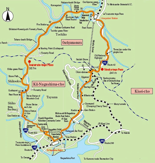
Umegadani Station → 1.7 Km 40 mins. → Tochiko (Fire Station) →1.4 Km 30 mins. →
Starting Point → 0.9 Km 30 mins. → Tsuzurato-toge Pass → 2 Km 40 mins. →
Shikooku Starting Point → 1 Km 20 mins. → Shiko /Route 422 → 2 Km 50 mins. →
Kii-Nagashima Station
Gateway to Kishu Overlooking the Kumano-nada Sea
About 9 Km, 3 hrs. and 30 mins. from JR Umegadani Station to JR Kii-Nagashima Station
Trails
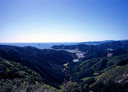
Tsuzurato-toge Pass was once the border between Ise and Kii Provinces. Pilgrims who traveled from Ise to Kumano were awed by a panoramic view of the Kumano-nada Sea when they reached the summit of Tsuzurato-toge Pass. “Tsuzurato” literally means “ninety-nine bends”.
It’s a zigzag path which stretches down from the summit of the pass to Shiko in
Kii-Nagashima-cho. On the way, a stone path covered with moss can be found in the forest.
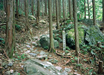 One can also see the original retaining stone walls on the steep side of the path.
Though this route was replaced with the Nisaka Route lying to the east after the Edo Period (1603 - 1868),
it was used by the local people till the beginning of the Showa Period (1926 - 1989).
Tsuzurato-toge Pass Route >>
Hadasu to Obuki-toge Pass Route >>
Nisaka-toge Pass Route >> Kannon-michi Path Route >>
Ikkoku-toge Pass to the Kumagaya-michi Path Route >>
Matsumoto-toge Pass to Hanano-iwaya Shrine Route >>
Hajikami-toge Pass Route >> Yokogaki-toge Pass Route >> Magose-toge Pass Route >> Fuden-toge Pass Route >> Crossing Yaki-yama Mount Route >>
Tori-toge Pass Route >> Miki-toge Pass to Hago-toge Pass Route >>
Kawabata(Kawatake)-kaido Road >> Sone-Jirozaka-Tarozaka Route
Hama-kaido Road Route(North) >> Nigishima-toge Pass to Okamizaka-toge Pass Route >>
Hama-kaido Road Route(South) >>