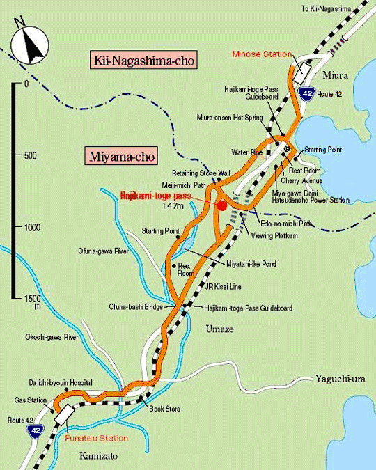
Minose Station → 1.1 Km 20 mins. → Starting Point → 1.7 Km 40 mins. →
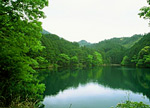
Hajikami-toge Pass → 2.1 Km 40 mins. → Miyatani-ike Pond → 1 Km 20 mins. →
Ofuna-bashi Bridge → 2.5 Km 40 mins. → Funatsu Station
Splendid Viewing Spot Where the Edo-no-michi Path and Meiji-no-michi Path Meet.
About 8.4 Km, 2 hrs. and 40 mins. from JR Minose Station to JR Funatsu Station
Trails
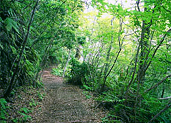 Hajikami-toge Pass forms the boundary between Kii-Nagashimacho and Miyama-cho. A national highway (Route 42) and the JR Kisei Line run through the tunnel right below the Pass. The starting point is at the back of the power station called“Miyagawa Daini Hatsudensho”. This route was recently reconstructed by the local community and even offers free walking sticks.
The area is breathtaking in spring when the trail is covered with cherry blossoms. One has a panoramic view of the sea, where a path used in the Meiji Period, on thenorthside of Route 42 meets with a path used during the Edo Period, on the southside of Route 42. On the pass Suzuki Bokushi created the following Haiku:
Hajikami-toge Pass forms the boundary between Kii-Nagashimacho and Miyama-cho. A national highway (Route 42) and the JR Kisei Line run through the tunnel right below the Pass. The starting point is at the back of the power station called“Miyagawa Daini Hatsudensho”. This route was recently reconstructed by the local community and even offers free walking sticks.
The area is breathtaking in spring when the trail is covered with cherry blossoms. One has a panoramic view of the sea, where a path used in the Meiji Period, on thenorthside of Route 42 meets with a path used during the Edo Period, on the southside of Route 42. On the pass Suzuki Bokushi created the following Haiku:
 大洋に潮の花や朝日の出
Oh-wadani ushio-no-hana-ya asa-hi-node
White caps of waves when the morning sun comes out of the ocean After viewing beautiful scenery, take the Meiji-no-michi Path to descend.
Tsuzurato-toge Pass Route >>
Hadasu to Obuki-toge Pass Route >>
Nisaka-toge Pass Route >> Kannon-michi Path Route >>
Ikkoku-toge Pass to the Kumagaya-michi Path Route >>
Matsumoto-toge Pass to Hanano-iwaya Shrine Route >>
Hajikami-toge Pass Route >> Yokogaki-toge Pass Route >> Magose-toge Pass Route >> Fuden-toge Pass Route >> Crossing Yaki-yama Mount Route >>
Tori-toge Pass Route >> Miki-toge Pass to Hago-toge Pass Route >>
Kawabata(Kawatake)-kaido Road >> Sone-Jirozaka-Tarozaka Route
Hama-kaido Road Route(North) >> Nigishima-toge Pass to Okamizaka-toge Pass Route >>
Hama-kaido Road Route(South) >>